In June of 1981 a group of people, organized by instructors of The Wilderness Center (TWC), decided on trying to climb Mt. Rainier in Washington State. At 14,410 feet it's the highest volcanic peak in the contiguous United States and has the largest alpine glacial system outside of Alaska. You can see it easily from Seattle.
At that time I was 19 years old just finishing my sophomore year at High Point. I had done at lot of canoeing, backbacking, winter camping and some rock climbing but never any mountain climbing. I was a cross country runner in High School and so I thought I was in good enough shape to try it.
The group from Greensboro trained together by doing a backpacking trip to Pilot Moutain. With packs loaded, up we hiked up to the top and rapelled down the rocks, hoping to simulate what was to come. Ralph Bell, who had been a TWC instructor, and was now working for Mt. Rainier National Park, was to join us.
On June 18th we flew out to Seattle via Atlanta. Ralph picked us up and we went to his place in Ashford WA. Ashford is just six miles outside the Nisqually Entrance to Mt. Rainier National Park and a great place to base camp. We stayed a day or so there then packed up and headed to our starting point at Paradise.
Welcome to Mountain Climbing
Paradise sits at 5,400 feet and averages 53 FEET of snow a year. When we arrived it looked like we were in the dead of winter. The parking lot had snow banks beside it of 10 to 15 feet tall, and you could not see the mountain, as it was shrouded in fog. Every climbing party has to register with the Mt. Rainier Guide Service. The building we had to register in was three stories tall, each story had a entrance door to accomodate the ever increasing snow over the year.
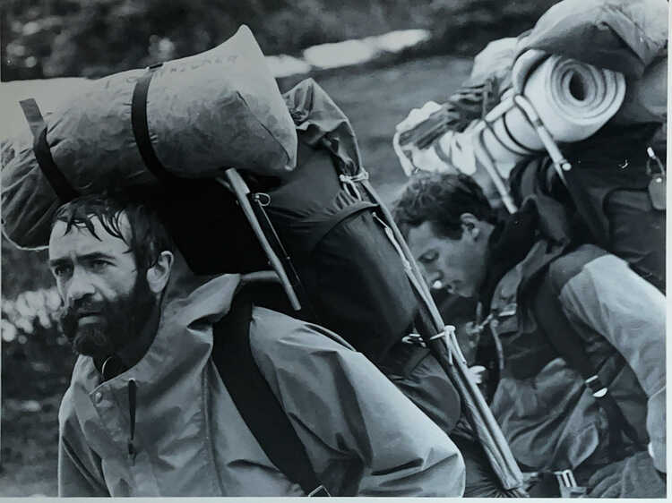
Most inexperienced climbers use the guide service. At that time it was run by Jim Whittaker and his twin Lou. Jim had been the first American to climb Everest in 1963. For a price, they take you up the mountain, providing your lodging, food and equipment. You only have to carry your personal equipment. However, we were an independent bunch, so we had to find our own way and carry everything we needed for the climb. So we put our loaded packs on and started towards Camp Muir which was at 10,000 feet and four miles away.
Within 300 feet of leaving the parking lot, I knew this was going to be hard. It was steep, my pack was very heavy and I was sweating and panting like a dog. Starting late only allowed us to get to Pebble creek two miles away. We found cover from the wind behind rocks and shoveled out tent platforms and made camp.
The next morning, still in the fog and whiteout, we started towards Camp Muir. It was very windy, cold and steep in places. By late afternoon, we were around 9000 feet, and we started getting glimpses of the mountain above us. I remember the clouds rushing past us as we began climbing above them. Finally getting to Camp Muir, we found a place to pitch our tents and settled in.
Normally, the next morning, you get up early and start for the summit. That night, as a group we decided we would take a rest day and go up the following morning.
Around midnight on Sunday June 21st, I woke up hearing other climbers preparing and roping up for the summit climb. I went back to sleep.
Avalanche
Next morning all were awaked by calls for help. Climbers were coming back saying there had been an accident and could anyone go up and help. I remember seeing one climber with cuts and blood on his face. My dad Ben, Paul Jones and Ralph Bell packed up and took off up the mountain. When they arrived, they could not see anything but blocks of ice and snow at the accident site.
It turned out that ten climbers and one guide, part of Rainier Mountaineering Inc., were buried by an immense avalanche of ice and snow on Ingraham Glacier at 11,000 feet. (See article). This was the largest mountaineering accident in the United States. Because of this accident, the park service stopped all climbing on the mountain. We were told more mountain guides were coming up and would help escort us down the mountain the next day. I remember the weather making a turn for the worse.
The next morning, my father and I went into the guide hut for a meeting. It turns out that both Jim and Lou Whittaker were in the meeting. They told us to prepare to descend to Paradise. So in a total whiteout and 50 mph winds we packed up, roped up and started down following the guides. At times, I could not see the other person on the same rope ahead of me.
No Communication
In 1981 there were no cell phones, so we had no way of communicating with our family to let them know we were ok. The local news started reporting an accident on Mt. Rainier that night and of course our families could only expect that the worst had happened. They were not reporting who had died or the details. It wasn't until late the next day, after we had gotten off the mountain, that we were able to call and let them know we were fine.
Another Attempt
After a few days of rest some of us wanted to try again, while others returned home. This time we decided on a "safer route" up the mountain, the Kautz route. We left again from Paradise but this time crossed the Nisqually glacier, and up the ridge where we camped. The next day was clear as we climbed up the steep Wilson glacier to "Camp Hazard" under the Kautz Ice Wall at 11,000 feet.
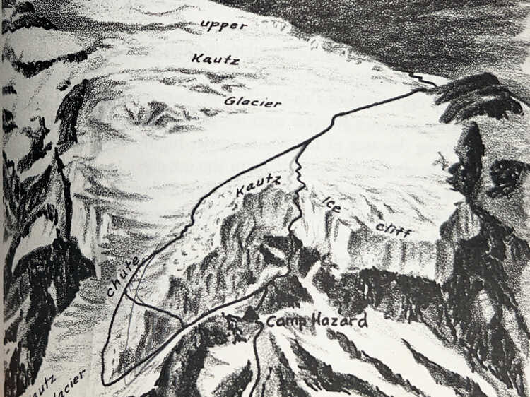
Another Avalanche
After supper we went to bed. Not soon after, as we were laying in our sleeping bags, we heard a loud crack above us. Then a loud sound of snow coming towards us. I heard someone scream from another tent "we are going to die". We braced for an impact but nothing happened, only a large gust of wind hit the tent. Apparently the avalanche had gone down the gullies on both sides of us. We unzipped the tent to find small ice chunks scattered around the camp.
The Summit
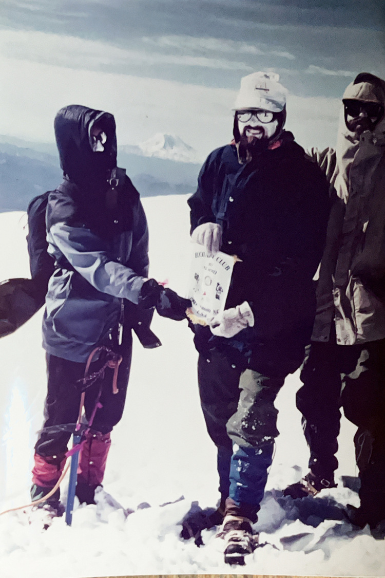
After a short sleep we got up at 2am. We roped up and crossed into the Kautz ice chute. The chute was steep and I remember seeing the outline of the next person on my rope team high above me. Around lunch we neared the summit. The last 100 feet felt like it took forever, as the altitude was catching up to me. At the summit, I remember looking out to the south and seeing Mt Hood and the Three Sisters in Oregon. We snapped some photos and we desended back to Camp Hazard. There we packed up and slid 2000 feet down the steeop Wilson glacier, crossed over the Nisqually glacier, and returned to Paradise.
Providence
Looking back I can only say that God's hand of protection was upon us. We were scheduled to be climbing at the same time and area as the climbers that were killed in the avalanche. We were also protected when the ice fell from the Kautz Ice cliff. Mountain climbing is very dangerous and you can't control some things, as I learned first hand.
Newspaper Aricles
Here are a few articles written by Bodie McDowell from the local paper, Greensboro News and Record, about the trip:
Article Before The Trip
Article After The Trip
Mount Saint Helens
After we returned to Ashford, we took an airplane ride around Mt. Saint Helens. It had erupted the year before on May 18, 1980. You could see the side of the mountain that was blown away and the inside. It was amazing the damage that was done. From our altitude the treeless mountains looked like someone had taken toothpicks and scattered them everywhere. The lakes were covered with floating trees as well.